Developing modern GIS applications removes a key barrier to running live, data-rich digital twins: it accurately locates every asset to its exact position. It shows its status the instant it changes. Conventional GIS tools rarely provide the full 3-D context, predictive power, or shared workspace that engineers, operators, and safety teams require. Smart Spatial bridges that gap by blending real-time telemetry, BIM data, and high-fidelity 3-D visuals into one operational twin. The platform delivers:
- Unified 3-D oversight with live system feeds — operators zoom from a campus view down to a single valve without juggling screens.
- Predictive maintenance and energy optimization are driven by heat maps and trend analytics, which are built on historical sensor data.
- Collaboration at scale: location-accurate training simulations and geospatial alerts that guide emergency response.
From immersive training modules to pinpoint mapping, today’s GIS application development accelerates workflows and equips decision-makers with hard data rather than guesswork when managing complex assets and infrastructure.
Role of GIS in Operational Digital Twins
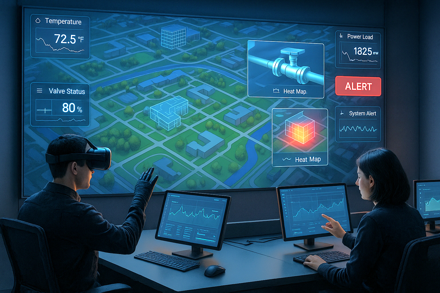
Geographic information systems act as the nervous system of an operational digital twin: they pin every asset to its accurate coordinates and stream live sensor readings into a 3-D model that updates the moment conditions change. Managers, engineers, and safety crews read that model like a real-time dashboard —seeing temperature flows, and loads exactly where they occur —so they correct faults before they disrupt production. The same engine continuously ingests telemetry, issues location-specific alerts when a metric drifts out of tolerance, and offers an immersive “X-ray” view that lets teams inspect pipes and cables behind walls without halting equipment.
Because spatial data and performance data now reside in the exact location, stakeholders no longer have to juggle flat diagrams and scattered charts. They zoom from a campus overview to a single valve, compare live readings with historical trends, and capture insights for predictive maintenance. The twin also doubles as a training ground: new staff walk through realistic scenarios and learn to isolate problems in a risk-free virtual environment. In short, GIS transforms the digital twin from a static visual model into an operational command center, reducing downtime, lowering maintenance costs, and streamlining every decision.
Integrating GIS Software with Live Facility Data
Effective digital twin operations depend on seamlessly integrating robust GIS software with real-time data streams. This integration enables continuous data ingestion from diverse telemetry sources, adhering to standards such as the OGC SensorThings standard, thereby creating a cohesive and accurate representation of facility conditions. By overlaying live sensor data onto precise spatial models, operational teams achieve comprehensive situational awareness that traditional monitoring systems cannot deliver.
This dynamic capability supports proactive decision-making. For instance, real-time data overlays enable the immediate identification of equipment that deviates from normal operational parameters, triggering automated geospatial alarms directly within the 3D environment. Consequently, personnel can respond rapidly with precise corrective actions, thereby enhancing safety and minimizing disruptions.
Illustration: Real-time 3D GIs and mapping interface showing live sensor data in a control room.
Smart Spatial’s GIS Development Workflow
A structured GIS development workflow enables organizations to rapidly transform complex BIM models and sensor inputs into production-ready digital twins. This approach leverages advanced geospatial services, powerful GPU-accelerated engines such as the Unity Industry Engine, and flexible data APIs, significantly surpassing legacy 2D mapping solutions in terms of speed, accuracy, and actionable intelligence.
The development process follows a clearly defined three-phase framework:
- BIM-to-Twin Conversion (1-2 weeks): Initially, BIM models, IFC files, or LiDAR scans are ingested and swiftly converted into high-fidelity 3D replicas using GPU-driven visualization engines. This allows immediate accessibility of interactive twins across desktop, mobile, and VR environments, drastically reducing deployment timelines.
- Data-Ingestion Sync Layer (1-3 months): Next, real-time telemetry from various operational systems (e.g., BMS, EMS, DCIM) is synchronized to create a unified data environment. This integration enables live, accurate monitoring, eliminating discrepancies and enhancing the responsiveness of decision-making.
- Custom Application Layer: The platform also supports tailored use-case implementations, including physics-based simulations and predictive scenario analyses. Users can explore complex "what-if" situations, simulate airflow or fluid dynamics, or create immersive training experiences within an interactive training module.
BIM-to-Twin Accelerators for Mapping GIS Data
Fast BIM-to-twin conversion hinges on advanced GIS mapping and GPU-accelerated rendering. Engines such as Unity Industry or Unreal Engine stream complex building geometry into fully interactive 3-D scenes, delivering an immersive view that flat maps cannot match.
These accelerators pull detailed IFC models or LiDAR scans, optimize them on the GPU, and publish a browser-, mobile-, or headset-ready twin with exact spatial accuracy. Teams can explore the model in real-time, overlay live sensor feeds, and drill from campus level to individual components for tasks ranging from asset tracking to emergency response. The result is sharper situational awareness, quicker decisions, and measurable gains in uptime and energy performance.
Illustration: Workflow diagram of BIM-to-Twin pipeline inside a real-time geospatial services viewer.
Key Features of a Scalable GIS System for 3D Visualization
A scalable GIS system unifies complex facility operations into a single 3D interface, eliminating inefficiencies caused by multiple siloed 2D screens. By integrating real-time telemetry, component-level visualizations, and two-way control capabilities, this approach enables operational clarity and immediate responsiveness. The transition from scattered data views to one comprehensive spatial representation significantly enhances situational awareness and decision-making efficiency.
Central to this GIS system is its powerful GPU-accelerated 3D visualization engine, which supports seamless cross-device access across desktop, mobile, VR, and AR platforms. Operators can interact directly with live data overlays, quickly identifying and addressing anomalies via integrated heat maps and geospatial alarms. Advanced time-machine replay capabilities further enable teams to analyze past incidents, optimize predictive maintenance schedules, and refine operational strategies.
Key features include:
- Live Telemetry Hub: Real-time integration of facility-wide sensor data for immediate operational insights.
- X-Ray Asset Layers: Detailed visualization of hidden components, simplifying asset management and maintenance planning.
- Time-Machine Replay: Historical event playback for root-cause analysis and predictive scenario testing.
- API-ready GIS System: Flexible interoperability with external data streams, enabling rapid integration with existing infrastructure.
- Cross-device VR/AR: Immersive access to operational data, guided by industry-standard WebGL best practices.
Looking ahead, adopting a unified 3D GIS approach positions enterprises to manage facility operations proactively, driving continuous efficiency gains and predictive reliability.
Illustration: Single 3D gis system dashboard replacing multiple 2D control panels.
Industry Use Cases for Geospatial Solutions
Cross-industry adoption of advanced geospatial solutions is transforming operational efficiency, safety, and sustainability. By leveraging platform-agnostic digital twins, organizations achieve measurable ROI, whether optimizing energy use, accelerating response times, or improving training outcomes. Real-time 3D visualization paired with live telemetry data enables proactive asset management and significantly enhances operational visibility.
Energy-Efficient Facility Management with Geospatial Services
Facility teams now pair geospatial twins with live telemetry to reduce power bills, minimize downtime, and demonstrate value to the C-suite.
- Data centers. CFD-driven twins plot rack temperatures in real time. A peer-reviewed study showed a 23.6% drop in cooling energy when operators tuned airflow using the model, while a Cadence white paper highlights further savings in fan and liquid-cooling costs.
- Smart campuses. Indoor GIS maps every camera, AED, and mechanical room, giving security staff live situational awareness and faster routing during incidents across multi-building sites.
- Manufacturing plants. Plants that overlay sensor data on a 3D twin experience 12–15% less unplanned downtime after adopting Industry 4.0 workflows.
- High-risk facilities. Immersive drills built on the twin let crews rehearse evacuations and equipment failures virtually; safety platforms report up to 45 % fewer incident-related stoppages and higher compliance scores.
By incorporating these geospatial dashboards into existing KPI reports and sales decks, facility managers translate technical wins —such as lower kWh, shorter outages, and faster response times —into clear financial impact.
Ultimately, deploying tailored geospatial platforms across various industries creates tangible value, driving improved sustainability metrics, operational efficiencies, and more informed strategic decisions.
Illustration: gis and mapping dashboard comparing energy load across multiple facilities.
Roadmap for Building a Custom GIS Application
A clear, time-boxed plan keeps a digital-twin project on budget and track:
1. Six-Week MVP
Start with a six-week minimum viable product that loads core spatial data, connects key telemetry feeds, and renders a live 3-D model. Utilize open APIs and standard file formats to ensure the prototype seamlessly integrates with existing building management and analytics systems without requiring custom integration. Early hands-on testing allows stakeholders to confirm that maps, data layers, and alerts behave as expected before significant investments are made.
2. Quarterly Feature Sprints
After the MVP, run three-month sprints. Each cycle delivers one or two high-value features —such as predictive maintenance dashboards or mobile AR views —and concludes with a governance checkpoint. The checkpoint reviews user feedback, verifies ROI against agreed metrics, and locks in the next sprint’s priorities, keeping the roadmap aligned with business goals.
3. Interoperability First
Build every new module against the same rules: industry-standard data formats, documented REST or gRPC APIs, and version-controlled schemas. This policy prevents data silos, shortens onboarding for new vendors, and makes future cloud migrations painless.
4. Scale-Out Rollout
The transition from pilot sites to the full estate only after load-testing query volumes, failover, and security controls are in place. Add compute nodes or cloud regions incrementally; the pay-as-you-grow model keeps costs predictable and avoids premature over-provisioning.
5. Continuous Calibration
Schedule bi-annual architecture reviews to check performance against new sensor volumes, edge-device standards, or regulatory requirements. Minor, regular adjustments cost far less than a one-off overhaul and keep the platform fit for next-generation workloads.
By pacing development through short, validated milestones—and baking interoperability and scalability into every layer—enterprises reduce project risk, realize benefits sooner, and keep the GIS twin adaptable to tomorrow’s demands.
Illustration: Project timeline illustrating milestones from MVP to enterprise-wide GIS rollout.
Adopting advanced 3D digital twins integrated with real-time GIS capabilities positions enterprises to transform operations, minimize risks, and achieve significant, measurable ROI. With improved spatial insight and predictive visibility, organizations across sectors — from data centers and campuses to manufacturing facilities — can make quicker, more confident decisions that directly enhance operational effectiveness. To unlock the full potential of your infrastructure through seamless digital integration, partner with Smart Spatial and take the first step toward implementing a robust, scalable solution tailored to your unique business objectives.